• Skip to primary navigation
  • Skip to main content
  • Skip to footer
  • Home
  • About Terramar
  • News
  • Support
  • Contact Us
Terramar Instruments

Terramar Instruments

Geophysical Equipment Sales and Rental

Geophysical Equipment Supplier
rentals@terramarinstruments.com | 317-998-2180 (New Number)
  • Equipment for Rent
  • Equipment for Sale
  • Manufacturers
    • Dualem
    • Falmouth Scientific
    • Hemisphere GPS
    • Impulse Radar
    • Leica Geosystems
    • Piletest Inc.
    • ZH Instruments
  • Request a Quote
  • About Terramar
  • Support
  • Contact Us
BIT | Borehole Inclination Tester

BIT | Borehole Inclination Tester

BIT measures the verticality of a borehole AND of existing piles

Borehole
BIT uses the auger/bucket itself as the centralizer. Eliminating the need for a heavy-to-move system.
The BIT enables fast and accurate determination of inclination in both dry and wet boreholes.
Large boreholes and diaphragm-walls may be quickly tested several times during drilling to enable real-time corrective action.
Existing piles:
A special centralizer is attached to the BIT sensor and lowered into a standard access tube (No need for an expensive inclinometer tube). The BIT sensor includes a gyro which constantly measures and compensates the rotation of the sensor in the tube.
Request a Purchase Quote
Category: Non-Destructive Testing Tags: Purchase New, Rental Brand: Piletest Inc. Piletest
  • Description

Description

Background

All piling specifications prescribe the allowable deviation of the pile axis from the vertical.

  • FHWA rules, for instance, limit the pile inclination to 20 mm/m, or 2%.
  • The ICE (UK) specifications allow a deviation of not more than 1:75 or 1.33%.

Similarly, these documents also set down the allowable deviation of raked piles.

In diaphragm and secant walls, the specification is typically even more restrictive.
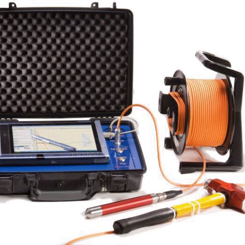
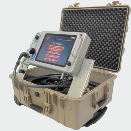
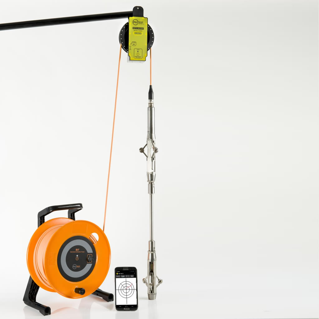
System components

  1. BIT Main unit, rechargeable battery operated with wireless communication channels to the depth meter (3), the mobile computer (4) and the rig operator box (5, not seen). Rugged polyurethane cable connects the main unit to the inclination sensor (2).
  2. Precision bi-axial inclination sensor, harsh environment and pressure proof to 300m, attached to the auger/bucket using a simple disposable metal plate.
  3. Precision wireless depth meter, transmitting accurate depth to the main box.
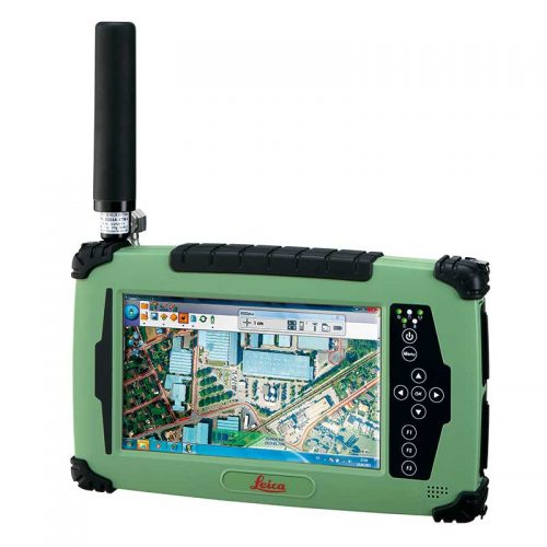
  4. Any Android mobile device with Bluetooth communication, (Phone/Tablet)
  5. Rig operator satellite box with two LEDs: GO/Stop (Optional)

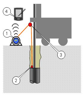
Operation for boreholes

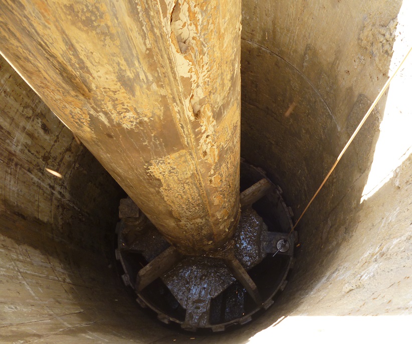
Once the borehole has been drilled to the required depth, the inclinometer is rigidly attached to the drill bit (bucket or auger) and the depth encoder hung from the rig. The bucket is then lowered (without turning) into the open hole. The descent is stopped at predetermined depths for inclination reading and the deviation calculated in real time by integrating the inclination over depth. Having reached the bottom, the procedure is repeated on the way up to the surface. The resulting error is distributed over the whole depth.

Operation for existing piles

A special centralizer is attached to the BIT sensor and lowered into a standard access tube through the depth encoder. The sensor is lowered by hand and the descent is stopped every few meters. reading stabilizes in a second or two and the process is repeated all the way down and back up  to ground level.  The resulting error is distributed over the whole depth.

Advantages:

  • Low-cost compared to traditional caliper systems
  • Quick to test (minutes per borehole)
  • User friendly wizard-driven software. No training needed. (Give it a try on your phone)
  • Works on any diameter

Downloads

  • BIT data sheet and technical specifications
  • BIT – User Manual

Related products

  • MALÅ CX

    MALÅ CX

    Read more
  • PSI | Parallel Seismic Instrument

    PSI | Parallel Seismic Instrument

    Read more
  • MALÅ Easy Locator HDR

    MALÅ Easy Locator HDR

    Read more
  • S321 GNSS Survey Smart Antenna

    S321 GNSS Survey Smart Antenna

    Read more

Footer

Terramar Instruments

rentals@terramarinstruments.com
317-998-2180 (New Number)

Contact Us

shipping address:
Terramar Instruments
4920 E23rd Street, Suite B
Indianapolis, IN 46218 USA

mailing address:
Terramar Instruments
4920 E23rd Street, Suite B
Indianapolis, IN 46218 USA

Quick Links

  • Rentals
  • Equipment for Sale
  • Manufacturers
  • Request a Quote
  • About Terramar
  • Support
  • Contact Us

Product Categories

  • Electrical Resistivity Imaging
  • Electromagnetics Systems
  • GPS
  • Ground Penetrating Radar
  • LiDAR
  • Magnetic Susceptibility Meters
  • Marine Seismic Systems
  • Non-Destructive Testing
  • Seismic Refraction and Reflection

Copyright © 2025 Terramar Instruments. All Rights Reserved.